PROJECT TITLE :
Ouādī 4.0 - Using digital technology to monitor floods in the city of Fez (Morocco)
COUNTRY :
Morocco
AN INCUBATION PROJECT SUPPORTED BY:
VERBATIM OF THE PROJECT LEADER :
« Founded in 2012, TENEVIA is a company specialised in the development of digital solutions for generating environmental data. The company has received numerous innovation awards, including the United Nations General Secretariat's award for natural hazard prevention (2015). The company puts digital technology at the heart of its technological and scientific approach. By exploiting two areas of Artificial Intelligence (AI), computer vision (image analysis) and digital modelling, TENEVIA's solutions provide access to unprecedented environmental measurements. Structured in four product families to meet different user needs, TENEVIA technology is available in the form of business software, sensors, simulators and online services. »
GEOGRAPHICAL LOCATION:
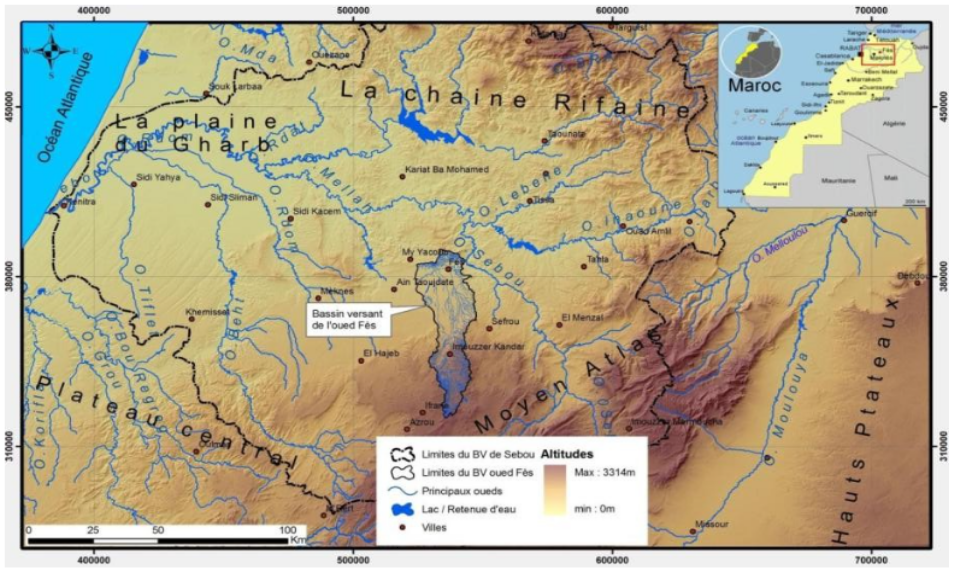
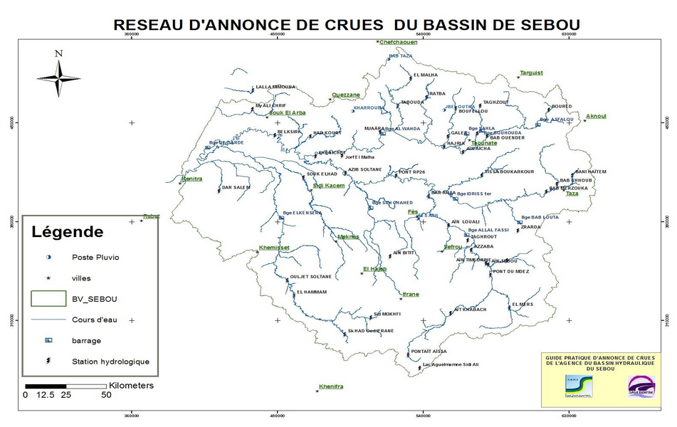
Hydraulic Basin of Sebou, Fez, Morocco
SCALE OF INTERVENTION:
Watershed
CONTEXT AND ISSUES OF THE TERRITORY:
Facing sudden and violent rainfall, the Kingdom of Morocco experiences major floods typical of Mediterranean climates. These extreme events, whose occurrence and intensity are increasing with the acceleration of climate change, have hardly affected the city of Fez (North-East Morocco). As the cultural capital of Morocco, the city's resilience to the risk of flooding is a major political issue. At the national level, all the urban areas of the Kingdom will have to adapt to the evolution of these "natural" phenomena.
 |
 |
| TENEVIA / Project site visit OUADI4.0 March, 2020 | You Tube / April flood, 2020 |
GOAL(S) OF THE PROJECT :
Violent floods and other extreme events require to deploy of adapted information systems, allowing the African city a better adaptation and sustainability to climate change.
Indeed, the Ouādī 4.0 project will allow the hydraulic management authority of the Fez catchment area to have new information (1), in order to better manage the floods caused by the various wadis that directly flow into the city. The project will also widen the anticipation horizon (2) of these rapid flood phenomena, thus favouring the alerting of the population in order to limit the loss of human lives but also economic losses.
(1) i.e. new information, produced by intelligent cameras out of the water, thus reducing the vulnerability of the measurement and monitoring network to floods. Based on image analysis, this non-contact measurement approach also facilitates the removal of doubt during crisis management. This technology also makes it possible to carry out gauging during floods, a decisive piece of information that is currently inaccessible with conventional solutions. A better knowledge of flood flows improves the performance of forecasting tools and provides more accurate information for the design of protection structures.
(2) i.e. To widen the anticipation horizon in order to ensure the safety of people and properties. The hydrometeorological forecasting chain enables extreme events to be anticipated from several hours to several days. The measurements made by the real-time monitoring network (e.g. cameras) are assimilated by the model, which has a self-adjusting capacity to ensure the reliability of the forecasts.
SDG TARGETED BY THE PROJECT :


PROJECT ISSUES:
Hydrological Measurement, Monitoring and Forecasting - Wadis - Intermittent rivers - Flash floods - Hydrometry by image analysis - Smart cameras
SECTORS CONCERNED:
Smart Cities
EXPECTED RESULTS:
- An innovative measurement and monitoring network based on intelligent cameras is set up;
- A video gauging software is designed;
- A flood forecasting model with real-time data assimilation is developed.

Medina of Fez, historical and cultural capital of Morocco classified as UNESCO world's heritage site - TENEVIA
STAKEHOLDERS OF THE PROJECT :
Actors involved:
- TENEVIA (French company);
- CENEAU (French company);
- SAGE Expertise (Moroccan company);
- Hydraulic basin of Sebou, (Moroccan administration);
- French Embassy in Morocco
Project Opérator(s) :
Hydraulic basin of Sebou, (Moroccan administration)
Technical partner(s):
- TENEVIA / CENEAU
- SAGE Expertise
Financial partner(s):
Ministry of the Economy, Finance and Recovery
ESTIMATED COST OF THE PROJECT::
450,000 €
SHORT-TERM ACTIONS (3 YEARS):
- Installation of a hydrometric measurement network (smart cameras)
- Installation of a rainfall measurement network (rain gauges)
- Implementation of a spatial hydrological forecasting model with data assimilation and auto-adjustable forecasts
- Supervisor for the visualization and concentration of the information produced;
- Training and video gauging software.
LONG TERM ACTIONS (10 YEARS) :
Pending