PROJECT TITLE:
SHARING SATELLITE OBSERVATIONS FOR SERVICE INNOVATION IN THE SENEGAL RIVER BASIN
COUNTRY:
Senegal
LOCATION :
Senegal River basin
SCALE OF INTERVENTION:
Regional
INCUBATION LED BY:


Map of the Senegal River © OMVS
LOCAL CONTEXT AND ISSUES:
The Senegal River basin, surrounded by semi-arid areas, is a regional life source shared by Guinea, Mali, Mauritania and Senegal. To work together to achieve sustainable water resources management, these riparian countries have organised themselves into a transboundary basin organisation: Organisation for the Development of the Senegal River (OMVS). In the current context of global warming, the issues facing the OMVS are numerous, including hydropower production, food security, water supply and the preservation of ecosystems. In order to meet the challenge of Integrated Water Resources Management, tools for hydrological and environmental monitoring are essential to inform decision-making.
The Diama Dam Management and Operating Company (SOGED) is responsible for managing water in the delta area and has worked with the Coteaux de Gasgone Development Company (CACG) to jointly build the tool MOSIS@SOGED to monitor irrigated land parcels. This tool processes satellite images to locate and quantify rice paddies submerged in water with the aim of improving the recovery of levies on withdrawals for irrigation.
The concerted approach taken by this MOSIS project, focused on the needs of final users, has led to the identification of needs for other services related to management of integrated water resources and associated ecosystems throughout the Senegal River basin.
PROJECT GOALS:
Build knowledge of tools to manage water resources and the environment in the Senegal River basin by developing these WEB services at different space and time scales to respond to clearly identified needs, such as:
- Monitoring the proliferation of typha in support of socio-economic enhancement processes
- Monitoring riverbank silting and erosion issues in order to anticipate the risk of instability and a decrease in water availability in the network
- Estimating water abstractions, in particular in the Bakel-Diama section, and monitoring planted areas to improve water management
- Monitoring deforestation and bush fires, in particular around spring catchment areas, to preserve the quality and quantity of water
SDGs TARGETED BY THE PROJECT:


CHALLENGES FACING THE PROJECT:
Water resources management – Climate change – Remote sensing – Service design – Senegal River basin – Levies on withdrawals for irrigation
SECTORS CONCERNED:
Agriculture – Energy – Biodiversity - Water security – Food security - Risk management (erosion, drought, flooding) – Protection and management of water and land ecosystems – User resilience
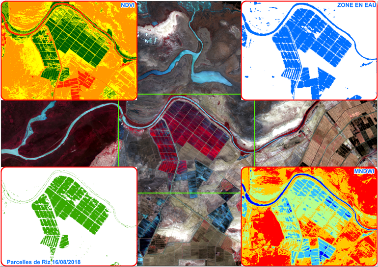
Processing chain of satellite images © OMVS
EXPECTED OUTCOMES:
New Information and Communication Technologies (NICT):
- Hydrological monitoring
- Monitoring of riverbank erosion in the Senegal River valley and soil degradation at spring catchment areas
- Monitoring of proliferation of invasive aquatic plants and protected wetlands
Modernisation and reinforcement of governance:
- Control of withdrawals
- Recovery of levies on withdrawals for irrigation
Capacity and knowledge building:
- Knowledge building and improved water management in a context of climate change (drop in rainfall and available river water)
PROJECT STAKEHOLDERS:
Stakeholders involved:
Organisation for the Development of the Senegal River (OMVS), OMVS management companies, stakeholders of the Senegal River basin
Project leaders:
OMVS, International Office for Water
Project operators:
OMVS, member states and associated managers
Technical partners:
CACG, E2L, CESBIO / CNES
Funder of the incubation process:
Adour-Garonne Water Agency
ESTIMATED COST OF PROJECTS IDENTIFIED FOR INCUBATION:
>1 million EUR
SHORT-TERM ACTION (3 YEARS)
- Joint construction of MOSIS WEB services with final users, taking a service design and Living Lab approach:
1. Listen to and analyse needs
2. Identify priority services with a high technological maturity index
3. Devise remote sensing and WEBGIS methods
4. Jointly devise web services with users
5. Validate VO and develop V1 web services
6. Define deployment conditions to achieve sustainability
7. Ensure operational implementation
8. Develop web services
LONG-TERM ACTION (10 YEARS)
- Management and sharing of knowledge at Senegal River basin scale
- Resource planning
- Management (monitoring of withdrawals, monitoring of invasive plants)
- Operation (infrastructure maintenance)